Xiuguluan River

Updated:2024-11-20
Popularity
84460Fun activities
- You can try the thrilling whitewater rafting during the rainy season from May to October every year
- Unique landscape of strange rocks at "Xiugu goggling jade"
- "Silk Road on the water" on the East Coast and cultural rafting "Tatadok"
- The only river in Taiwan that cuts through the Coastal Range
Feature
- History and CultureHistory and Culture"Xiuguluan" is derived from the word "Ciporan" in Amis dialect. The original meaning is "at the estuary." This was originally the old name of Gangkou Village, and later was adopted as the name of the river and the name of the mountain.
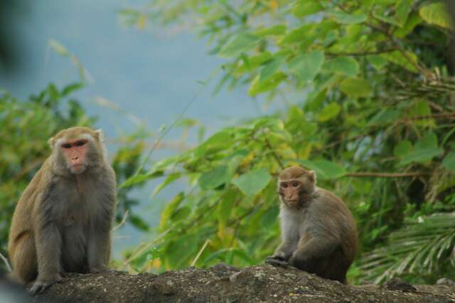
The Amis are the oldest indigenous people in the Xiuguluan River Basin. During the Japanese rule, the Bunun people were forced to move to the west of Xiuguluan River. At the same time, a Japanese immigrant village was established in Changliang Village of Yuli. Only until late Qing dynasty did the Han people gradually move in. - Nature and ecologyNature and ecologyXiuguluan River is one of the few unpolluted rivers in Taiwan. There are more than 30 kinds of freshwater fish in the water. Among them, the Taiwan Ku fish, which is listed as a protected species is the most precious. On both shores of the downstream valley, there are still remaining tropical rain forests. Among the mammals, the Formosan rock macaque is the easiest to see. About 100 species of birds have been found here. The natural and ecology here are rich.
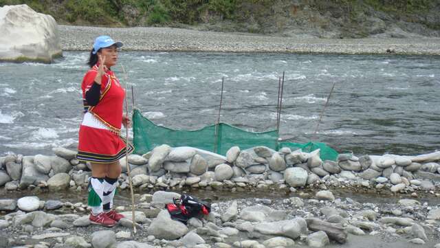
- Qimei TribeQimei TribeQimei is located in the middle of the Coastal Range in Ruisui Township, Hualien County; mid-stream Xiuguluan River. Surrounded by mountains, it is blessed with beautiful scenery. Winding valleys and layered river terraces make the landscape in Qimei unique.
"Qimei" is the translation of Kiwit in the Amis language. Originally it refers to a kind of tough vine-like fern, Japanese climbing fern, which can be used to bind things. By extension, it means that the tribe's life is as tough as the fern. The Qimei tribe still follows strictly the age hierarchy. it today. The fishing festival and harvest festival are also still held in traditional ways. Their music and dance play a very important role in Amis culture, especially the percussion instrument made of bamboo and wood, Kokag; and the Ciopihay dance performed by young men at the harvest festival. - Xiuguluan River Visitor CenterXiuguluan River Visitor CenterXiuguluan River Visitor Center is located next to Ruisui Bridge in the East Rift Valley. It is the starting point for rafting activities on Xiuguluan River. The Center's appearance models after traditional indigenous buildings. There is a huge, exquisite indigenous totem in the center square. The exhibitions on the 1st and 2nd floors of the Center showcase the ecological resources of Xiuguluan River where rafting is conducted. In the screening room, rafting safety video is shown. The Center also has a camping area. During the rafting season, this area is crowded with tourists.
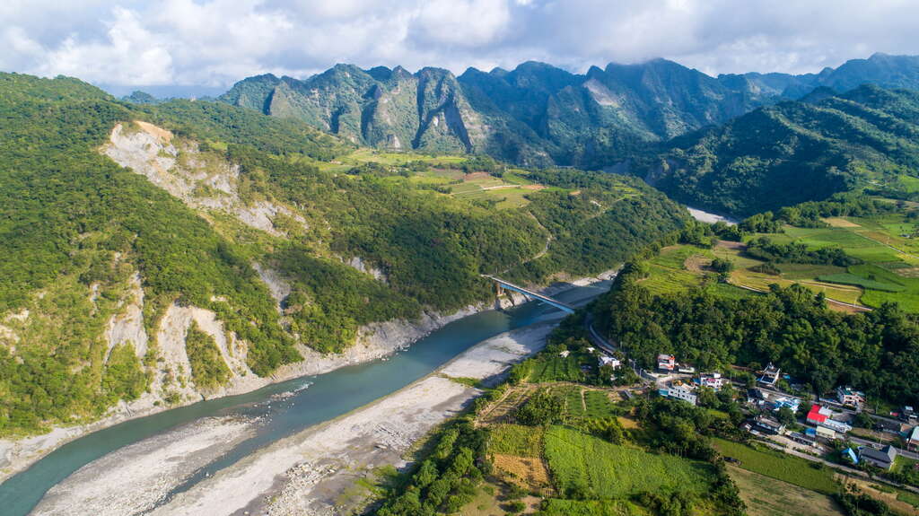
- Xiedewu Terrace and Qimei Grand CanyonXiedewu Terrace and Qimei Grand CanyonLook forward from the observation deck on Ruigang Highway, what looks like an amphitheater is Xiedewu Terrace. This is where Xiuguluan River turns eastward.
Xiuguluan River flows from south to north along the East Rift Valley to Dewu Terrace. It immediately turns eastward and begins to cut through the Coastal Range. A beautiful "meander" is formed on one bank, and a terrace is formed on the other bank. The river terrace has 5 stories. Further toward the north the river terrace becomes lower in height, and a more suitable environment for farming and living.
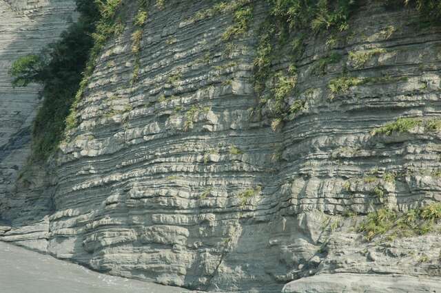
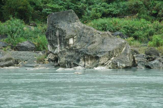
In Qimei, you can see the magnificent terrain like a canyon. If you look closely, it is stacked one layer on top of another, like a mille-feuille. It was originally composed of sandstone and mudstone. Because the stream has more impact on the soft layer than the hard layer, the majestic mille-feuille landscape is born. - 12 Zodiac stone12 Zodiac stoneWhere Xiuguluan River flowing past the old Changhong Bridge, the river suddenly widens. Giant limestones known as imperial stones scatter on the riverbed. After years of water erosion, they became rocks of strange shapes, "Wanwuxiang (the faces of all creatures)." The rock is as white as jade, so it also was given the name "Xiugu Goggling Jade."
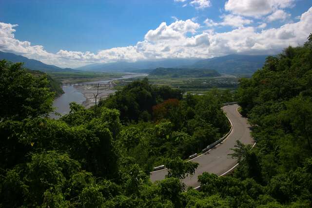
In the early spring of March and April each year, it is the best time to go to the downstream of Xiuguluan River in Hualien County to see Xiugu Goggling Jade. The strange rocks are shaped like tigers, leopards, lions, elephants, and phoenixes. Some look like the holy tortoise ascending to heaven, the Guanyin lotus throne, or Zhu Bajie and Beethoven. Here, all visitors can realize their potentials for artistic creation, everything can look like something if you believe so. - Ruigang HighwayRuigang HighwayRuigang Highway is another way to enjoy the scenery of Xiuguluan River Valley. This road that runs from Ruisui to the west and along the side of Xiuguluan River is about 22.5 kilometers long, most of which are based on the old road built by Qing dynasty leader, Wu Guangliang. With the beautiful scenery along the road and the rafting activities, it has become the most attractive sightseeing road among the three roads that go through the Coastal Range.
Xiuguluan River cuts through the Coastal Range, making many steep canyons which best showcase the geological structure. Landscapes such as meanders and river terraces caused by the stream are well developed, making this place a great natural classroom for geology and topography.
From Ruigang Highway, which is built by the mountains and the river, you can see the rafts on Xiuguluan River during the peak season. The scene of people rowing with full strength and dedication and fighting against the rapids is very exciting. In addition, early morning or dusk are the best times for bird watching.


Details
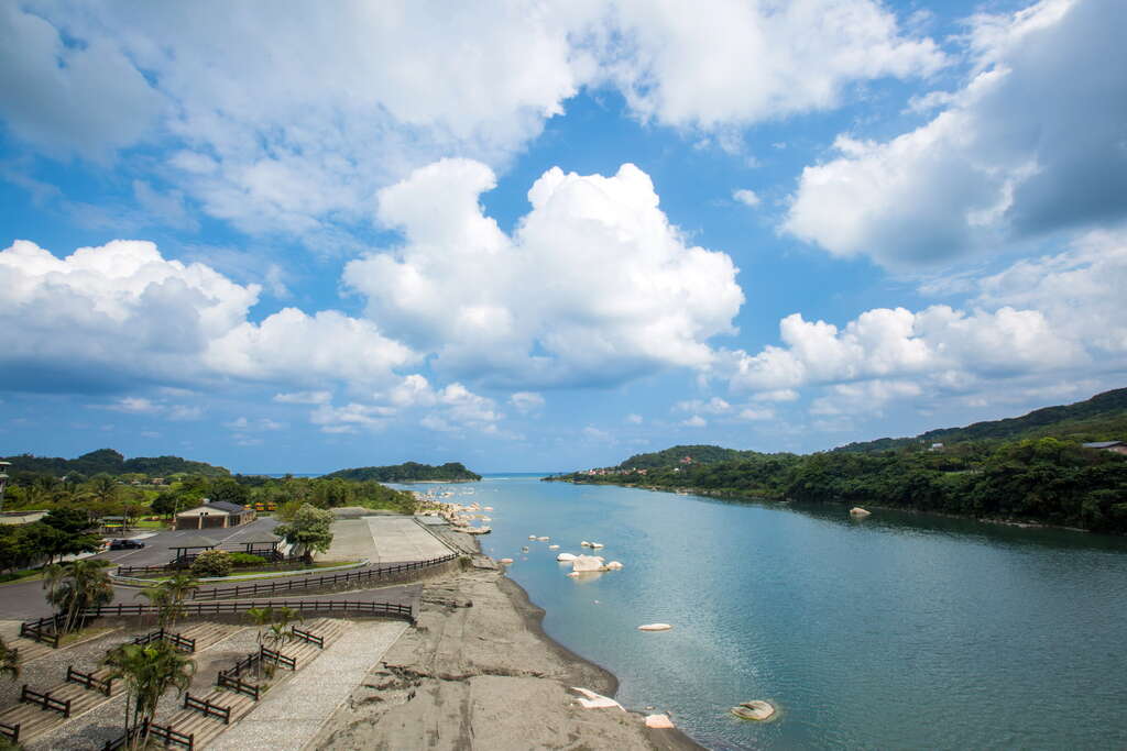
The 104-kilometer-long Xiuguluan River originates from the Central Range and is the largest stream in eastern Taiwan, cutting through Coastal Range and flowing into the sea. The cutting and erosion of the stream for many years have cut many steep gorges, created meanders, river steps, and other landscapes, as well as shaped the sedimentary rocks of the mountains on both sides into a variety of landscapes. The huge stones commonly known as the imperial stone are as white as jade and have beautiful lines are named, "Xiugu goggling jade."
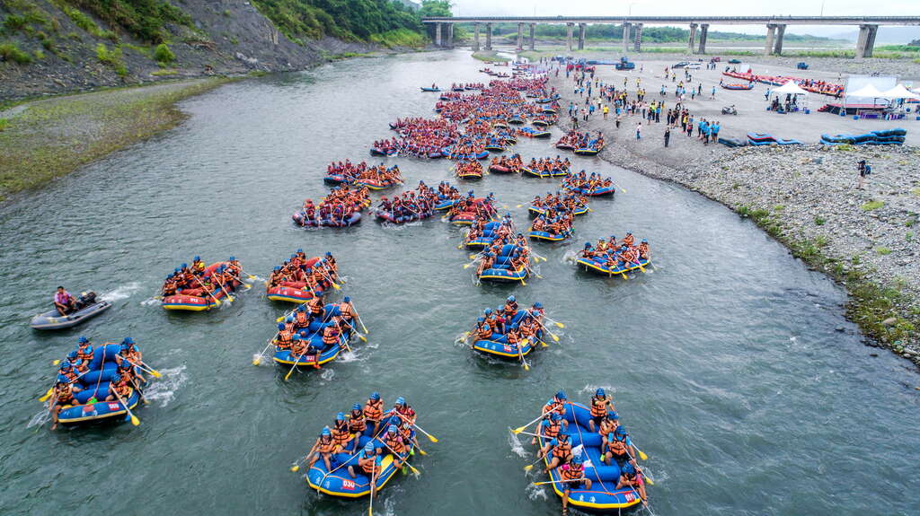
An absolutely thrilling rafting experience
The best time for rafting: the high-water season from May to October each year
Rafting time: about 3-4 hours
Midway stop: Qimei rafting rest stop
The best way to experience Xiuguluan River is definitely rafting! Departing from Ruisui Bridge and going all the way down the river, passing through thrilling rapids, crossing the Qimei Suspension Bridge, and finally arriving under Changhong Bridge at the estuary of Xiuguluan River, the beautiful scenery on both sides of shores is all in your view. At the same time, you must dodge the hidden whirlpools and the sudden rapids. Experience the soaking wet adventure of 100% excitement!
The strange rocks on Xiuguluan River
Ruigang Highway that follows along Xiuguluan River is an excellent route for observing the terrain and landscape of the Coastal Range. The best two spots are Qimei Grand Canyon and Xiugu Goggling Jade. Along the western section of Xiuguluan River, you can see that sandstone and shale are alternately layered, like a giant mille-feuille—Qimei Grand Canyon is famous for it. In contrast, Xiugu Goggling Jade in the riverbed of the lower Xiuguluan River is port limestone.
Information
Open Time
/Always open.
Facilities
- Brief explanation
- Visitor Centre
- Exhibition Hall
- Parking lot
- Toilets
- View Point
How to Get There
Choose a transportation method based on your departure location. Remind
1.While rafting, please ensure to follow the rafting safety rules.
2.Summer sun can be harmful, please take precautions.
3.Next to the River, it is necessary to pay attention to safety
4.After heavy rain, please check road conditions in advance and watch out for landslides and falling rock on the road.
2.Summer sun can be harmful, please take precautions.
3.Next to the River, it is necessary to pay attention to safety
4.After heavy rain, please check road conditions in advance and watch out for landslides and falling rock on the road.